Road run-off
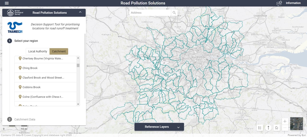
Click here to view Road Pollution Solutions Tool.
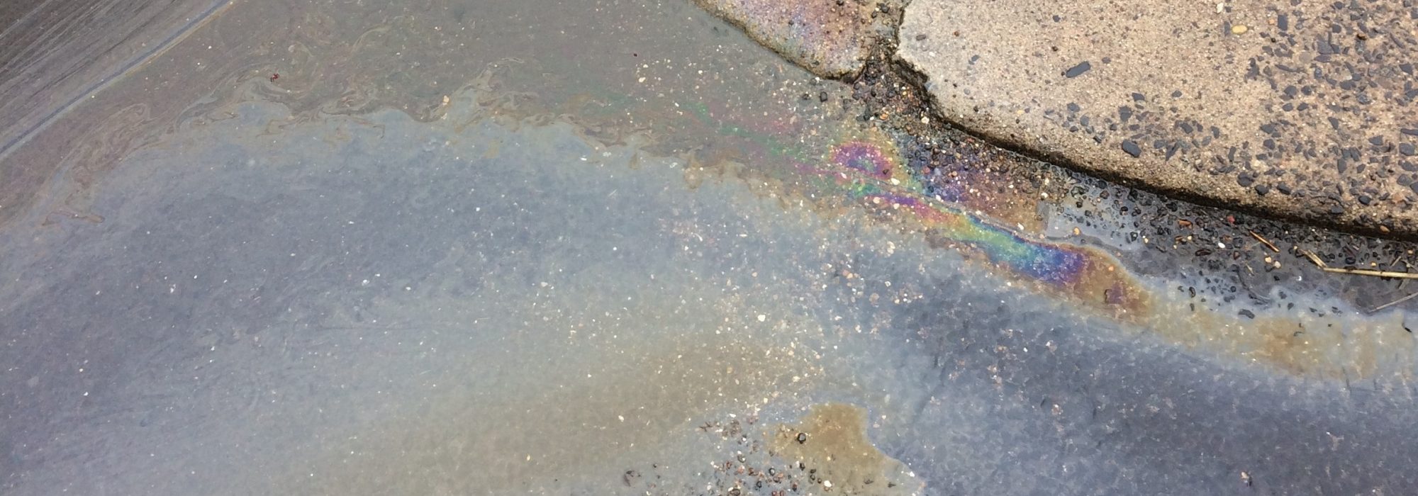
London’s rivers are more polluted than they should be. There are many reasons for this. They include untreated sewage released by water companies, illegal waste dumping and littering and misconnected drains. There is also another type of pollution known as road runoff. Road runoff occurs when pollutants that settle on the surface of the road – such as residue from oil spills, as well as tyre and brake wear from vehicles – build up during dry weather and are then washed into rivers and streams when it rains.
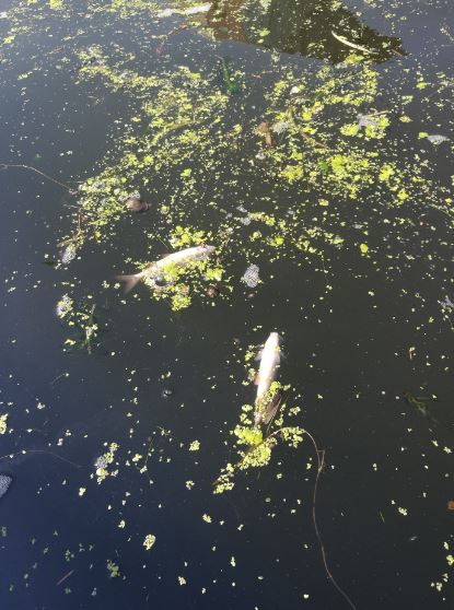
The long-term impacts of road run-off pollutants are not fully understood, but the short-term effects can be acute and contribute to fish kills in so-called ‘first flush’ events. These events happen when it rains after a long dry period. During the dry period, the problem occurs when, chemicals and other organic materials build up on our roads making them more concentrated. So, when it eventually rains, this sediment is washed into London’s rivers. The pollution drives up nutrient levels in the water, which boosts algal growth. The growing algae suck all the oxygen out of the water, leaving fish struggling to breathe. In the worst instances, they die.
Until now, road runoff pollution has been notoriously difficult to track and tackle because of its intermittent nature – occurring after rainfall – and because it occurs simultaneously from multiple outfalls across a catchment. Also, the most polluting roads may be some way from the outfall where they enter and impact the river. Now, we have a tool that can help borough councils, catchment partnerships and local residents understand which roads in their local area are most polluting and which possible treatment options they should use.
Project Team: Environment Agency, Zoological Society of London (ZSL) and the Greater London Authority (GLA) funded Thames21 and Middlesex University to develop a new road runoff risk characterisation and SUDS decision model. The project was supported by South East Rivers Trust.
The British Geological Survey, as part of the Community Water Management for a Liveable London (CAMELLIA) programme, have played a vital part in bringing the underpinning model to life and developing the visualisation as a user-friendly web-based decision support tool.
First phase
Thames21 led the first phase of a partnership project with Middlesex University and ZSL (funded by the Environment Agency, Transport for London and the Greater London Authority) quantifying the amount of pollution from roads entering our rivers. This report uses ‘big data’ from transport models to calculate the quantity of pollutants deposited on roads from traffic throughout the capital.
The first phase of the study, which took place in 2019, identified roads of varying levels of priority that have the greatest potential to contribute towards pollution in London’s rivers, to help identify the best locations for interventions to address this issue.
Second phase
Four years later (2023), this second phase of the project has created an online, interactive and evidence-based decision tool (Road Pollution Solutions Tool) that predicts the pollution risk posed by London’s strategic road network, identifies pollution pathways into the river and guides and prioritises where and how nature-based solutions can be used to tackle road runoff pollution.
The modelling is limited to outer London as this area has a separate surface water drain system. Surface water is rainwater that collects from roofs, driveways, drains and gutters. In outer London it drains directly to rivers through a separate surface water sewage system, whereas central London has a combined drainage system, where surface water drains alongside domestic foul water pipes to sewage treatment works (if it is not overloaded).
To our knowledge, this work, is the first attempt at this scale to develop an evidence-based strategy for the characterisation and resolution of road runoff. It is important to note that whilst nature-based solutions can be used to tackle road runoff pollution, source control should be the priority intervention in reducing the quantity of pollutants from entering our waterways.
The Road Pollution Solutions Tool is a great first step towards prioritising the most polluting roads but this work needs further development; a Phase 3.
Maidenhead – Teddington Catchment and Surrey
Thames21 has now expanded the tool to cover the Maidenhead to Teddington catchment area and have also modelled Surrey. A consortium of three water companies (SE Water, Thames Water and Affinity Water) commissioned Thames21 to evaluate the feasibility of developing the road runoff model in their area of interest: the Lower Thames catchment, from Maidenhead to Teddington, with a view to then delivering the model as a second phase of works. This first (scoping) phase assessed data availability and gaps in order to estimate costs to deliver the model; and engaged local authorities to gauge their willingness to implement model outputs. During this engagement process, Surrey County Council expressed interest in commissioning extension of the road runoff model to cover their entire area – only a small portion of the county falls within the Maidenhead-Teddington catchment area.
South East Water, Surrey County Council and the Environment Agency went on to fund the model to be produced for the catchment and county area.
Independent researchers from Imperial College London were commissioned via Imperial Consultants to develop an annual average daily traffic model for the catchment area of Maidenhead – Teddington and Surrey.
To find out about the changes made to underlying inputting data layers and the methodology please refer to the documents below.
Third Phase
The Road Pollution Solutions Tool is a great first step towards prioritising the most polluting roads, but this work needs a further phase 3.
To read more about the Road Pollution Solutions Tool please refer to the below documents: