Building Resilience in Communities (BRIC)
Thames21 is empowering communities in Canvey Island, Essex, to co-create solutions to flooding with public authorities as part of an exciting two-year pilot project funded by the European Union. Building Resilience in Communities (BRIC) is a €3.4 million initiative led by Plymouth City Council.
The project has secured 70% grant funds from the Interreg France-Channel-England programme.
The project will give residents the chance to help shape solutions to flood management by developing systems and procedures to share power and responsibility more equally with the public bodies that have traditionally dealt with the issue.
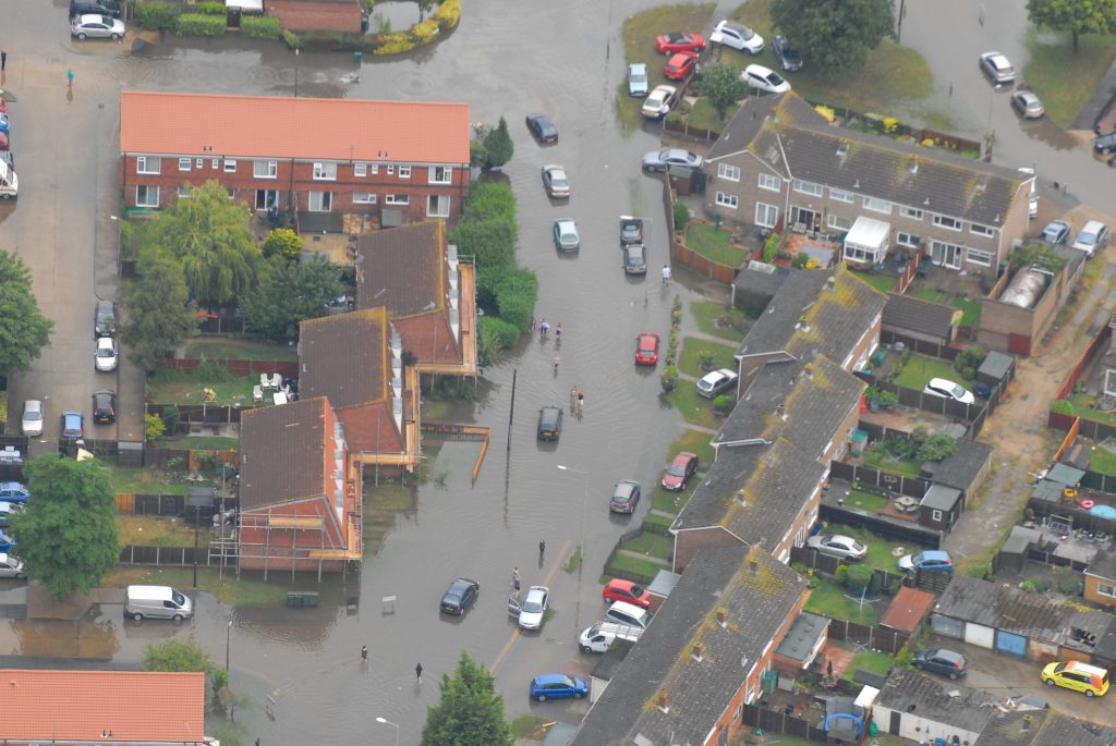
Flooding costs France and England about €870m annually. This figure is expected to rise by 25-80%
by 2100. In addition, projected sea level rises resulting from climate change threatens more than 100,000 buildings in the France (Channel) England area.
Flood risk management (FRM) is a highly technical public service, traditionally delivered in a top down approach by public authorities. From the public’s point a view, finding solutions to flooding risk can be a slow process, with uncertain time frames. Therefore, there can be resistance to behavioural change within the community.
The project aims to address this by involving the community in assessing the problem. Residents will be given the chance to understand and chart the issues and to work with authorities to find the solutions. These new social innovation methods will bring communities and flood risk management authorities together, help adapt areas facing flood risk to make them more resilient to climate change whilst supporting economic recovery at neighbourhood level.
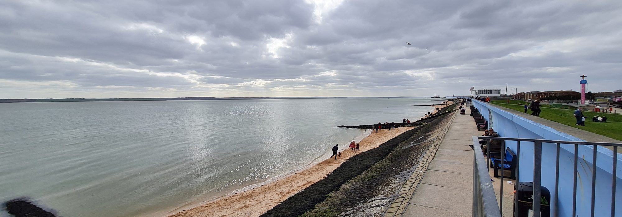
Canvey Island vulnerable to flooding
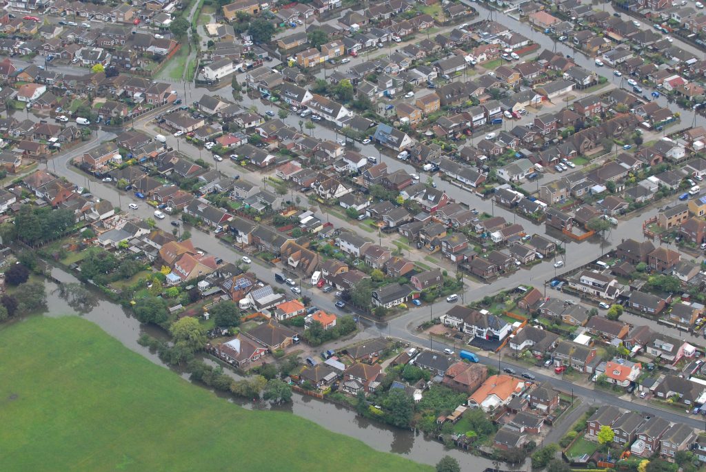
Canvey Island is located on the South East coast of Essex in the Thames estuary. The island was originally a salt marsh before being reclaimed by sea waters in the 7th Century. It has an area of 7.12 square miles (18.44 km2) and a population of 40,000 (around 16,000 homes). In the first half of the 20th century it was the fastest growing sea resort in the UK but was devastated by floods in 1953. The area is largely urbanised and it includes some wards that are ranked among the most deprived areas in England in terms of academic achievement, income and health.
It has been chosen as one of the project’s eight pilot areas because it is highly vulnerable to flooding from both sea and surface water. Canvey is protected from tidal surges by its sea wall. The Canvey Island southern shoreline revetment project will maintain the existing high level of tidal flood risk protection to thousands of homes, businesses and infrastructure on Canvey Island into the future (works are expected to start in 2022-23). Canvey has suffered from extensive surface water flooding in recent years.
Community-led approach
As one of the eight BRIC partners, Thames21 is running a pilot using the charity’s experience in training and empowering communities to address issues affecting waterways in London.
Thames21 is creating a new resilience network, facilitating the integration of community-led action with various stakeholders (Anglian Water, Castle Point Borough Council, Essex County Council and the Environment Agency). New governance arrangements to deliver new services, training, and community mapping will empower neighbourhoods to take action to protect themselves, become flood resilience ambassadors in their own community and work with authorities on solutions.
Pilot activities include:
- Building a network of local stakeholders (residents, community groups, land owners, local businesses, local governments, technical agencies, NGOs)
- Working with this network to co-create a flood resilience action plan for Canvey Island, including a community emergency plan
- Working with local people to map flood issues and potential solutions
- Running practical events to build skills and the community’s understanding of flood risk management
- Developing and delivering a new course “Leading Action for Local Flood Resilience”, as part of Thames21’s accredited waterways training course programme, based on community priorities.
Outputs
- Local flood resilience network
- Co-created flood resilience action plan
- Leading Action for Local Flood Resilience accredited training course
- Practical engagement events to build skills and understanding within the community
- Work with communities to map flood issues and potential solutions
- Canvey Island flood resilience story map
Overall, the BRIC project will create eight community flood resilience networks, six skills development schemes for disadvantaged people, a community-based hazard analysis framework and a toolkit on best practice and guidance. A web platform will also be created partner OgoXe to collate all the knowledge about new methods and lessons learned, with the aim of transforming flood risk management.
Combined, the aims of the pilot projects are that:
- 70% of participants will be better prepared for flooding
- 30% of participants will record improvement in their health and wellbeing
- 30% of participants will report improved trust with local government
- €350m will be saved in avoided losses and costs from flooding across the project region
Contact us
Anyone wanting to get involved or find out more about the project can get in touch with Thames21’s BRIC Canvey Island Engagement Officer:
Kate Monson: 07597 578116 or via email at Kate.Monson@thames21.org.uk
Alternatively, email: CanveyIslandBRIC@thames21.org.uk
Project partners
Partners in the overall BRIC project bring a range of different skills and experiences:
- Plymouth City Council (the lead partner). Unitary authority incorporating strategic planning, parks and highways maintenance and Lead Local Flood Authority.
- National Flood Forum. Representing communities at risk of flooding, and supporting self help through formation of flood action groups.
- Thames21, an environmental charity and Rivers Trust based in London which works to improve rivers, connect communities, and provide training on caring for waterways and issues affecting them.
- Dorset County Council / Dorset Coastal Forum. Lead Local Flood Authority, and Forum to foster collaboration between coastal stakeholders
- Cerema (Centre d’études et d’expertise sur les risques, l’environnement, la mobilité et l’aménagement). A national agency providing advice and support regarding a wide range of environmental issues, including flood risk management and urban design.
- L’Oise La Vallee (Agence d’Urbanisme et de Développement de la Vallée de l’Oise). An urban planning agency, providing services on-demand to Communes in Vallee de L’Oise
- CPIE d’Authie (Centre Permanent d’initiatives pour, l’environment d’Authie). An environmental and community education NGO.
- OGoXe. A tech company providing flood warning and environmental monitoring services.